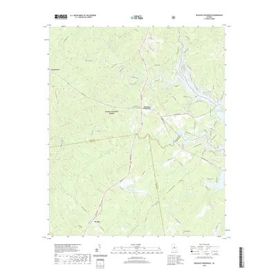
2020 Map of Resseaus Crossroads
USGS Topo · Published 2020About this map
Resseaus Crossroads serves as a central junction where local routes converge amidst the wooded expanse of the Oconee National Forest. This region, split by the boundaries of Jones, Putnam, and Baldwin counties, is defined by its hydraulic network, most notably the inlets of Lake Sinclair and the flow of Murder Creek. Small rural settlements like Ethridge and Stanfordville are connected by a web of roads such as Old Hwy 11 and Gray Rd SW, which navigate a landscape punctuated by family landmarks and historical burial sites including Key Cem and Stiles Cem. The presence of Upper Hawkins Lake and Lower Hawkins Lake further illustrates the management of water resources in this part of Georgia. For genealogists and local historians, the specific placement of these cemeteries and named creek branches like Hitchcock Br and Baker Br provides essential spatial context for tracing early homesteads and land use patterns.
Find a feature on this map
76 named features on this map. Tap any name to fly to it.
Don’t see what you’re looking for? This feature index may not catch every label — zoom into the map to look around manually.
Map Details
Editions of this 2020 Resseaus Crossroads Map
This is the sole edition of this map. No revisions or reprints were ever made.
Other maps of this area

1953 · Athens
USGS Topo · 1:250,000

1958 · Athens
USGS Topo · 1:250,000

1959 · Athens
USGS Topo · 1:250,000

1963 · Athens
USGS Topo · 1:250,000

1964 · Gray
USGS Topo · 1:24,000

1964 · Stanfordville
USGS Topo · 1:24,000

1972 · Meda
USGS Topo · 1:24,000

1972 · Eatonton
USGS Topo · 1:24,000
1972 · Smithboro
USGS Topo · 1:24,000
1972 · Browns Crossing
USGS Topo · 1:24,000