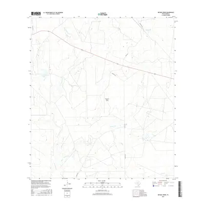
2016 Map of Retama Creek
USGS Topo · Published 2016About this map
Retama Creek and its surrounding drainage systems define the landscape of this Webb County ranching corridor in South Texas. The area is characterized by an intricate network of intermittent waterways, including the winding San Juanito Cr and Lobo Cr, which flow toward localized catchments and estate reservoirs. Artificial and managed water sources like Killam Lake Number 1 and Hirsch Estate Lake are prominent landmarks, reflecting the vital role of water management in this arid environment. Transportation and access are primarily managed through private and ranch roads such as Mangana Hein and Pescadito Rd. The Santa Maria Ranch Airport stands as a focal point for aviation and logistics within the larger ranch holdings, illustrating the modern infrastructure supporting large-scale land use and resource management in the region during the early 21st century.
Find a feature on this map
15 named features on this map. Tap any name to fly to it.
Don’t see what you’re looking for? This feature index may not catch every label — zoom into the map to look around manually.
Map Details
Editions of this 2016 Retama Creek Map
This is the sole edition of this map. No revisions or reprints were ever made.
Other maps of this area

1933 · Becerra Creek
USGS Topo · 1:62,500

1937 · Aguilete Creek
USGS Topo · 1:62,500

1940 · Aguilares
USGS Topo · 1:62,500

1956 · Laredo East
USGS Topo · 1:62,500

1956 · Laredo
USGS Topo · 1:250,000

1965 · Tios Creek
USGS Topo · 1:24,000

1980 · Blancas Creek North
USGS Topo · 1:24,000
1980 · Agua Azul Creek East
USGS Topo · 1:24,000
1980 · Mirando City
USGS Topo · 1:24,000
1980 · Burrito Tank
USGS Topo · 1:24,000