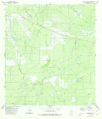
1980 Map of Retama Creek
USGS Topo · Published 1980About this map
San Juanito Creek and Retama Creek dominate this Webb County landscape, carving intricate drainage patterns through the brush country. The map documents an area defined by its energy production and infrastructure during the late 1970s, with a significant Oil Field and numerous Oil Wells, Drill Holes, and a Gas Well scattered across the terrain.
Find a feature on this map
17 named features on this map. Tap any name to fly to it.
Don’t see what you’re looking for? This feature index may not catch every label — zoom into the map to look around manually.
Map Details
Editions of this 1980 Retama Creek Map
This is the sole edition of this map. No revisions or reprints were ever made.
Other maps of this area

1933 · Becerra Creek
USGS Topo · 1:62,500

1937 · Aguilete Creek
USGS Topo · 1:62,500

1940 · Aguilares
USGS Topo · 1:62,500

1956 · Laredo East
USGS Topo · 1:62,500

1956 · Laredo
USGS Topo · 1:250,000

1965 · Tios Creek
USGS Topo · 1:24,000

1980 · Blancas Creek North
USGS Topo · 1:24,000
1980 · Agua Azul Creek East
USGS Topo · 1:24,000
1980 · Mirando City
USGS Topo · 1:24,000
1980 · Burrito Tank
USGS Topo · 1:24,000