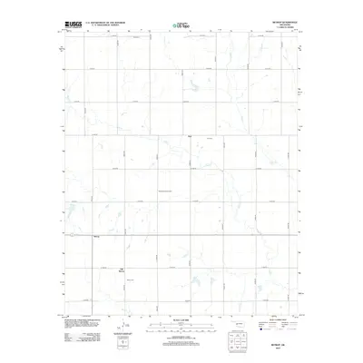
2012 Map of Retrop
USGS Topo · Published 2012About this map
Retrop and its predecessor, Old Retrop, anchor this section of Washita County, illustrating the shifting centers of local life in rural Oklahoma. The landscape is defined by the section-line road grid, where names like Clark Cemetery, Port Cemetery, and Retrop Cemetery provide essential markers for genealogists and local historians tracking early families. This 2012 survey captures the area's continued reliance on natural resources and agriculture, evidenced by the West Sentinel Oil Field located west of the main settlements. The terrain is drained by the winding courses of Elk Creek and Trail Creek, which cut across the geometric precision of the county roads. The transition from the original townsite at Old Retrop to the more modern settlement of Retrop further north highlights the evolution of this farming community over the preceding century.
Find a feature on this map
24 named features on this map. Tap any name to fly to it.
Don’t see what you’re looking for? This feature index may not catch every label — zoom into the map to look around manually.
Map Details
Editions of this 2012 Retrop Map
This is the sole edition of this map. No revisions or reprints were ever made.
Other maps of this area

1955 · Clinton
USGS Topo · 1:250,000

1957 · Clinton
USGS Topo · 1:250,000

1957 · Dill City
USGS Topo · 1:62,500

1961 · Hobart
USGS Topo · 1:62,500

1961 · Retrop
USGS Topo · 1:62,500

1961 · Elk City
USGS Topo · 1:62,500

1983 · Dill City
USGS Topo · 1:24,000

1984 · Sentinel
USGS Topo · 1:24,000
1984 · Cambridge
USGS Topo · 1:24,000

1985 · Elk City
USGS Topo · 1:100,000