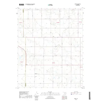
2018 Map of Retrop
USGS Topo · Published 2018About this map
The boundary between Beckham Co and Washita Co divides this rural Oklahoma landscape, where the shifting center of community is visible in the relationship between Retrop and Old Retrop. Located in the southwestern portion of the map, these settlements reflect the typical prairie town pattern of relocation driven by changing transportation corridors. The terrain is defined by the dendritic drainage patterns of Elk Creek and its tributary, Trail Creek, which carve into the rolling plains. Genealogical interest is centered on three distinct burial grounds: Retrop Cemetery, Port Cemetery near the northern settlement of Port, and Clark Cemetery at the northern edge. The strict section-line grid of roads, including N2030 Road and E1250 Road, anchors the landscape, tracing the paths of early twentieth-century land development.
Find a feature on this map
41 named features on this map. Tap any name to fly to it.
Don’t see what you’re looking for? This feature index may not catch every label — zoom into the map to look around manually.
Map Details
Editions of this 2018 Retrop Map
This is the sole edition of this map. No revisions or reprints were ever made.
Other maps of this area

1955 · Clinton
USGS Topo · 1:250,000

1957 · Clinton
USGS Topo · 1:250,000

1957 · Dill City
USGS Topo · 1:62,500

1961 · Hobart
USGS Topo · 1:62,500

1961 · Retrop
USGS Topo · 1:62,500

1961 · Elk City
USGS Topo · 1:62,500

1983 · Dill City
USGS Topo · 1:24,000

1984 · Sentinel
USGS Topo · 1:24,000
1984 · Cambridge
USGS Topo · 1:24,000

1985 · Elk City
USGS Topo · 1:100,000