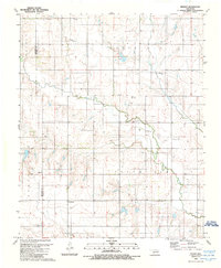
1989 Map of Retrop
USGS Topo · Published 1989About this map
Retrop and Port anchor this Western Oklahoma landscape along the Beckham Co Washita Co boundary in the late 1980s. The region is defined by the diverging paths of North Elk Creek and South Elk Creek, where the local economy and geography are shaped by numerous Gas Wells and Oil Wells. A distinct shift in the townsite location is evidenced by the presence of Old Retrop to the south of the current settlement, a common occurrence in rural communities following changes in transportation or infrastructure. Genealogists will find several burial grounds across the plains, including Retrop Cem, Port Cem, and Clark Cem, which serve as quiet markers of the families who settled this prairie. The survey reflects a specialized industrial footprint through the presence of a notable Pipeline and a Drill Hole landmark, indicating active extraction efforts during this era.
Find a feature on this map
13 named features on this map. Tap any name to fly to it.
Don’t see what you’re looking for? This feature index may not catch every label — zoom into the map to look around manually.
Map Details
Editions of this 1989 Retrop Map
This is the sole edition of this map. No revisions or reprints were ever made.
Other maps of this area

1955 · Clinton
USGS Topo · 1:250,000

1957 · Clinton
USGS Topo · 1:250,000

1957 · Dill City
USGS Topo · 1:62,500

1961 · Hobart
USGS Topo · 1:62,500

1961 · Retrop
USGS Topo · 1:62,500

1961 · Elk City
USGS Topo · 1:62,500

1983 · Dill City
USGS Topo · 1:24,000

1984 · Sentinel
USGS Topo · 1:24,000
1984 · Cambridge
USGS Topo · 1:24,000

1985 · Elk City
USGS Topo · 1:100,000