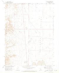
1968 Map of Reveille SE
USGS Topo · Published 1973About this map
The Reveille Range dominates the western half of this 1968 survey, its steep contours giving way to the broad flats of Railroad Valley to the east. This specific study was conducted by the Geological Survey in cooperation with the Atomic Energy Commission, reflecting the strategic and scientific importance of this high-desert region during the late 1960s. The landscape is marked by minimal human infrastructure, characterized primarily by an unimproved Jeep Trail and a single Gravel Pit. Notable geographic markers include the summit labeled Hungry, which provides a distinct vertical reference point overlooking the valley floor. The map precisely delineates township and range boundaries, including the intersection of T. 3 N. T. 2 1/2 N. and R. 52 E. R. 53 E., capturing the stark, undeveloped character of the Nye County interior.
Find a feature on this map
8 named features on this map. Tap any name to fly to it.
Don’t see what you’re looking for? This feature index may not catch every label — zoom into the map to look around manually.
Map Details
Editions of this 1968 Reveille SE Map
This is the sole edition of this map. No revisions or reprints were ever made.
Other maps of this area

1908 · Kawich
USGS Topo · 1:250,000

1942 · Reveille Peak
USGS Topo · 1:125,000

1942 · Penoyer Valley
USGS Topo · 1:125,000

1952 · Reveille Peak
USGS Topo · 1:62,500

1954 · Caliente
USGS Topo · 1:250,000

1954 · Goldfield
USGS Topo · 1:250,000

1955 · Goldfield
USGS Topo · 1:250,000

1956 · Lund
USGS Topo · 1:250,000

1956 · Tonopah
USGS Topo · 1:250,000

1958 · Goldfield
USGS Topo · 1:250,000