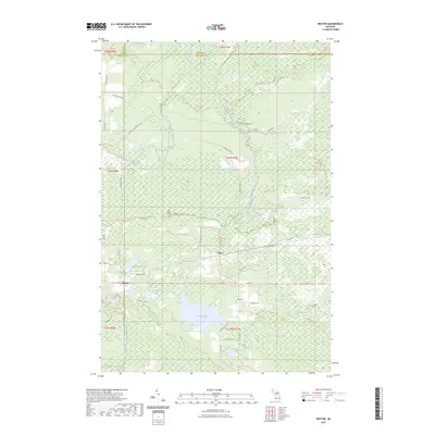
2023 Map of Rexton
USGS Topo · Published 2023About this map
Rexton and Caffey anchor this Upper Peninsula landscape, where the marshy lowlands of the Hiawatha National Forest region are defined by an intricate network of water and timber-access routes. The terrain is marked by numerous small lakes and ponds, including Strouble Lake, Rexton Lake, and the larger Fiborn Pond near the center of the sheet. Modern recreational use is evident through specialized paths like the Newberry-rexton Motorcycle Trail and the Brevort-trout Lake Motorcycle Trail. Historic industrial ties are visible in names such as Fiborn Quarry Road and Dinkey Line Road, hinting at the area's logging and mining heritage. The map also captures the Caffey Cemetery and several remote water bodies such as Ryerse Lake and Little Lake, providing a clear view of this rural corner of Mackinac County where the West Branch Hendrie River and South Branch Hendrie River begin their slow trek through the wetlands.
Find a feature on this map
46 named features on this map. Tap any name to fly to it.
Don’t see what you’re looking for? This feature index may not catch every label — zoom into the map to look around manually.
Map Details
Editions of this 2023 Rexton Map
This is the sole edition of this map. No revisions or reprints were ever made.
Other maps of this area

1931 · Epoufette SE
USGS Topo · 1:31,680

1931 · Epoufette NE
USGS Topo · 1:31,680

1931 · Epoufette NW
USGS Topo · 1:31,680

1931 · Epoufette SW
USGS Topo · 1:31,680

1931 · Gilchrist NE
USGS Topo · 1:31,680

1951 · Hulbert
USGS Topo · 1:24,000

1951 · Eckerman
USGS Topo · 1:24,000

1951 · Eckerman
USGS Topo · 1:62,500

1954 · Sault Sainte Marie
USGS Topo · 1:250,000

1956 · Sault Sainte Marie
USGS Topo · 1:250,000