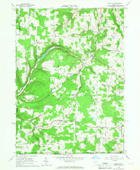
1965 Map of Rexville
USGS Topo · Published 1967About this map
Bennetts Creek carves a deep valley through the high hills of southern Steuben County, anchoring a landscape defined by small rural hamlets and upland farming. In the mid-1960s, these remote settlements remained connected by a network of winding township roads such as Christian Hollow Rd and Keenan Road. The map reveals a community centered around faith and memory, with numerous family and parish sites like St Marys Ch and Hauber Cem scattered across the ridges. Industrial activity is concentrated in the creek bottoms and lower slopes, evidenced by several Gravel Pits and scattered Gas Wells. The southern boundary transition into Pennsylvania is marked by smaller drainages like Wileyville Brook and White Branch, where the terrain begins to flatten toward the state line near the hamlet of Wileyville.
Find a feature on this map
79 named features on this map. Tap any name to fly to it.
Don’t see what you’re looking for? This feature index may not catch every label — zoom into the map to look around manually.
Map Details
Editions of this 1965 Rexville Map
2 editions found
Other maps of this area

1899 · Gaines
USGS Topo · 1:62,500

1900 · Gaines
USGS Topo · 1:62,500

1926 · Wellsville
USGS Topo · 1:62,500

1926 · Greenwood
USGS Topo · 1:62,500

1932 · Genesee
USGS Topo · 1:62,500

1937 · Genesee
USGS Topo · 1:62,500

1950 · Elmira
USGS Topo · 1:250,000

1954 · Williamsport
USGS Topo · 1:250,000

1954 · South Canisteo
USGS Topo · 1:24,000

1954 · Troupsburg
USGS Topo · 1:24,000