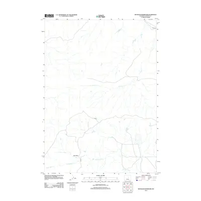
2012 Map of Reynolds Reservoir
USGS Topo · Published 2012About this map
Beck Place stands as a focal point in this high-plains landscape of Natrona County, where the infrastructure of ranching and remote travel defines the layout of the land. The drainage of N Fork Casper Cr and Cloud Cr carve subtle pathways through the terrain, suggesting the importance of seasonal water in this arid region. The road network, including the aptly named Divide Rd and 33 Mile Rd, underscores the distances and topographical boundaries encountered by those working the land in the early twenty-first century. These thoroughfares, along with Beck Rd, connect isolated holdings and offer a clear view of how rural land management and local geography have shaped the development of this Wyoming interior.
Find a feature on this map
6 named features on this map. Tap any name to fly to it.
Don’t see what you’re looking for? This feature index may not catch every label — zoom into the map to look around manually.
Map Details
Editions of this 2012 Reynolds Reservoir Map
This is the sole edition of this map. No revisions or reprints were ever made.
Other maps of this area

1955 · Arminto
USGS Topo · 1:250,000

1958 · Arminto
USGS Topo · 1:250,000

1962 · Arminto
USGS Topo · 1:250,000

1968 · Merino
USGS Topo · 1:24,000

1968 · Camel Hump Reservoir
USGS Topo · 1:24,000

1968 · Reynolds Reservoir
USGS Topo · 1:24,000

1968 · Big Sulfur Draw
USGS Topo · 1:24,000

1968 · Fiftymile Flat
USGS Topo · 1:24,000
1968 · Burlington Lake
USGS Topo · 1:24,000
1968 · Anderson Draw
USGS Topo · 1:24,000