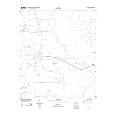
2011 Map of Reynolds
USGS Topo · Published 2011About this map
The town of Reynolds serves as the central hub of this Georgia landscape, situated where the terrain meets the meandering Flint River. This survey captures the rural character of Taylor County at the beginning of the 21st century, defined by a network of local routes like General John B Gordon Rd and Hilton Rd that connect outlying settlements. Small residential clusters and historic names such as Beechwood, Nakomis, and Potterville appear alongside family-named landmarks and water bodies. The area is heavily influenced by the drainage patterns of Beaver Creek and Patsiliga Creek, which feed several localized reservoirs including Wainwright Lake and Brunson Lake. For the local historian, the map preserves the exact locations of several community burial grounds, from the Glover Cemetery in the north to Mount Olive Cemetery in the south near Horse Creek, offering a detailed record of the county's social geography.
Find a feature on this map
45 named features on this map. Tap any name to fly to it.
Don’t see what you’re looking for? This feature index may not catch every label — zoom into the map to look around manually.
Map Details
Editions of this 2011 Reynolds Map
This is the sole edition of this map. No revisions or reprints were ever made.
Other maps of this area

1955 · Phenix City
USGS Topo · 1:250,000

1956 · Fort Valley
USGS Topo · 1:62,500

1957 · Phenix City
USGS Topo · 1:250,000

1957 · Macon
USGS Topo · 1:250,000

1958 · Macon
USGS Topo · 1:250,000

1958 · Phenix City
USGS Topo · 1:250,000

1964 · Macon
USGS Topo · 1:250,000

1971 · Fickling Mill
USGS Topo · 1:24,000

1971 · Reynolds
USGS Topo · 1:24,000
1971 · Roberta
USGS Topo · 1:24,000