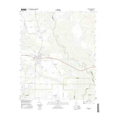
2017 Map of Reynolds
USGS Topo · Published 2017About this map
Reynolds sits at the heart of this landscape, positioned along the E Fall Line Freeway where the higher ground descends toward the wetlands of the Flint River basin. To the east, the terrain is defined by the winding course of Patsiliga Cr, which feeds into the dense Magnolia Swamp and Beechwood Swamp. This area is characterized by a complex network of creeks and branches, including Black Bottom Cr and Fraser Br, which drain the lowlands surrounding settlements like Beechwood and Nakomis. Genealogy researchers will find several small burial sites scattered throughout the countryside, such as Glover Cem near Crowell Church Rd and the White Hill Cem farther south. The map illustrates the 21st-century configuration of local infrastructure, showing the relationship between family-named roads like Zack Posey Rd and the larger water bodies like Ricks Lake and Brunson Lake.
Find a feature on this map
82 named features on this map. Tap any name to fly to it.
Don’t see what you’re looking for? This feature index may not catch every label — zoom into the map to look around manually.
Map Details
Editions of this 2017 Reynolds Map
This is the sole edition of this map. No revisions or reprints were ever made.
Other maps of this area

1955 · Phenix City
USGS Topo · 1:250,000

1956 · Fort Valley
USGS Topo · 1:62,500

1957 · Phenix City
USGS Topo · 1:250,000

1957 · Macon
USGS Topo · 1:250,000

1958 · Macon
USGS Topo · 1:250,000

1958 · Phenix City
USGS Topo · 1:250,000

1964 · Macon
USGS Topo · 1:250,000

1971 · Fickling Mill
USGS Topo · 1:24,000

1971 · Reynolds
USGS Topo · 1:24,000
1971 · Roberta
USGS Topo · 1:24,000