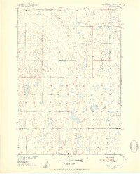
1951 Map of Rezac Lake NW
USGS Topo · Published 1951About this map
Glacial potholes and small prairie lakes dominate this landscape in north-central South Dakota, as seen in the early 1950s. The area is divided by the border of Faulk Co and Hyde Co, showing a rural settlement pattern defined by townships like Ellisville, Latham, Seneca, and Union. This survey illustrates the importance of local education in the mid-century agrarian economy, specifically marking the East Ellisville Sch and School No 13 along the sectional road grid. The presence of an Old Railroad Grade cutting across the southeastern corner suggests a shift in the local transportation network, where a former rail line had already been decommissioned. In the south, the headwaters of Medicine Cr begin to take shape among the undulating terrain, while a small Gravel Pit indicates local resource extraction used for maintaining the area's unimproved dirt roads.
Find a feature on this map
10 named features on this map. Tap any name to fly to it.
Don’t see what you’re looking for? This feature index may not catch every label — zoom into the map to look around manually.
Map Details
Editions of this 1951 Rezac Lake NW Map
2 editions found
Other maps of this area

1950 · Rezac Lake NE
USGS Topo · 1:24,000

1950 · Rezac Lake
USGS Topo · 1:24,000

1951 · Rezac Lake NE
USGS Topo · 1:24,000

1951 · Rice Lake
USGS Topo · 1:24,000

1951 · Rezac Lake
USGS Topo · 1:24,000

1951 · Rezac Lake NW
USGS Topo · 1:24,000

1952 · Burkmere
USGS Topo · 1:24,000

1952 · Onaka SW
USGS Topo · 1:24,000

1953 · Huron
USGS Topo · 1:250,000

1954 · Aberdeen
USGS Topo · 1:250,000