
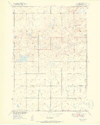
1951 Map of Rezac Lake
USGS Topo · Published 1951About this map
The boundary of Hyde Co and Hand Co divides this 1950s landscape, which is defined by a sparse network of prairie section lines and rural infrastructure. Local education is anchored by schoolhouses such as Weiss Sch, Eden Sch, and Ontario Sch, serving the surrounding agricultural townships of Banner, Harrison, Eden, and Ontario.
Find a feature on this map
12 named features on this map. Tap any name to fly to it.
Don’t see what you’re looking for? This feature index may not catch every label — zoom into the map to look around manually.
Map Details
Editions of this 1951 Rezac Lake Map
2 editions found
Other maps of this area

1949 · Ree Heights NW
USGS Topo · 1:24,000

1949 · Mitchell Lake
USGS Topo · 1:24,000

1950 · Highmore NE
USGS Topo · 1:24,000

1950 · Mitchell Lake
USGS Topo · 1:24,000

1950 · Rezac Lake NE
USGS Topo · 1:24,000

1950 · Rezac Lake
USGS Topo · 1:24,000

1951 · Rezac Lake NE
USGS Topo · 1:24,000

1951 · Rice Lake
USGS Topo · 1:24,000

1951 · Ree Heights NW
USGS Topo · 1:24,000

1951 · Orient SW
USGS Topo · 1:24,000