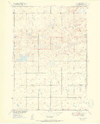
1951 Map of Rezac Lake
USGS Topo · Published 1951About this map
The county line between Hyde Co and Hand Co divides a sparsely populated prairie landscape in this 1951 survey, conducted for the Department of the Interior’s Missouri River Basin development program. The map documents a rural community supported by local institutions, including Weiss Sch, Eden Sch, and Ontario Sch, alongside the Bohemian Cem which marks the heritage of the area's early settlers. The terrain is characterized by alkaline basins and wetlands, most notably Rezac Lake and the drainage of Lost Creek. Land use is defined by townships such as Banner, Harrison, and Ontario, where the presence of a Windmill underscores the reliance on groundwater in this part of South Dakota. The survey, compiled from 1948 aerial photography and 1950 plane-table methods, provides a precise look at the section lines and unimproved roads that networked these remote farmsteads.
Find a feature on this map
11 named features on this map. Tap any name to fly to it.
Don’t see what you’re looking for? This feature index may not catch every label — zoom into the map to look around manually.
Map Details
Editions of this 1951 Rezac Lake Map
2 editions found

Other maps of this area

1949 · Ree Heights NW
USGS Topo · 1:24,000

1949 · Mitchell Lake
USGS Topo · 1:24,000

1950 · Highmore NE
USGS Topo · 1:24,000

1950 · Mitchell Lake
USGS Topo · 1:24,000

1950 · Rezac Lake NE
USGS Topo · 1:24,000

1950 · Rezac Lake
USGS Topo · 1:24,000

1951 · Rezac Lake NE
USGS Topo · 1:24,000

1951 · Rice Lake
USGS Topo · 1:24,000

1951 · Ree Heights NW
USGS Topo · 1:24,000

1951 · Orient SW
USGS Topo · 1:24,000