
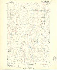
1951 Map of Rezac Lake NW
USGS Topo · Published 1951About this map
The boundary between Faulk Co and Hyde Co defines the southern portion of this mid-century survey, conducted as part of the Department of the Interior's Missouri River Basin development program. The landscape is marked by the distinct townships of Seneca, Latham, Ellisville, Union, and Banner, where a network of section roads and small water bodies like Medicine dictate the pattern of rural life. Local education and industry are captured through the presence of rural schoolhouses, including East Ellisville Sch and School No 13, alongside a small Gravel Pit.
Find a feature on this map
11 named features on this map. Tap any name to fly to it.
Don’t see what you’re looking for? This feature index may not catch every label — zoom into the map to look around manually.
Map Details
Editions of this 1951 Rezac Lake NW Map
2 editions found
Other maps of this area

1950 · Rezac Lake NE
USGS Topo · 1:24,000

1950 · Rezac Lake
USGS Topo · 1:24,000

1951 · Rezac Lake NE
USGS Topo · 1:24,000

1951 · Rice Lake
USGS Topo · 1:24,000

1951 · Rezac Lake
USGS Topo · 1:24,000

1952 · Burkmere
USGS Topo · 1:24,000

1952 · Onaka SW
USGS Topo · 1:24,000

1953 · Huron
USGS Topo · 1:250,000

1954 · Aberdeen
USGS Topo · 1:250,000

1954 · Huron
USGS Topo · 1:250,000