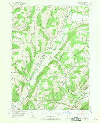
1953 Map of Rheims
USGS Topo · Published 1955About this map
Fivemile Creek serves as the central drainage for this section of Steuben County, carving a valley followed by the Kanona & Prattsburgh RR. The agricultural and small-town character of the mid-1950s is evident in the cluster of hamlets such as Wheeler, Mitchellsville, and Rheims. To the south, the Cohocton River valley and the Erie RR anchor the settlement of Kanona. This survey reveals a landscape of high ridges like Wheeler Hill and Harrisburg Hill interspersed with numerous country cemeteries and rural religious landmarks, including the Wheeler Hill Ch. Near the southeastern corner, the proximity to the Finger Lakes region is signaled by Keuka Inlet and the settlement of Pleasant Valley, where the terrain begins to drop toward the lake basin.
Find a feature on this map
46 named features on this map. Tap any name to fly to it.
Don’t see what you’re looking for? This feature index may not catch every label — zoom into the map to look around manually.
Map Details
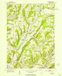
Editions of this 1953 Rheims Map
2 editions found
Other maps of this area

1900 · Naples
USGS Topo · 1:62,500

1903 · Naples
USGS Topo · 1:62,500

1903 · Penn Yan
USGS Topo · 1:62,500

1903 · Hammondsport
USGS Topo · 1:62,500

1910 · Bath
USGS Topo · 1:62,500

1913 · Naples
USGS Topo · 1:62,500

1942 · Naples
USGS Topo · 1:31,680

1942 · Prattsburg
USGS Topo · 1:31,680

1942 · Pulteney
USGS Topo · 1:31,680

1950 · Elmira
USGS Topo · 1:250,000