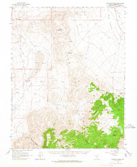
1963 Map of Rhyolite Ridge
USGS Topo · Published 1965About this map
Silver Peak Range dominates this mid-century topographic survey of Esmeralda County, revealing a landscape defined by mining prospects and desert hydrology. The rugged terrain is punctuated by historic routes and high points like Emigrant Peak and Emigrant Pass, while the broad Big Smoky Valley and Lake Valley occupy the lowlands. Localized water sources, critical for survival and industry in this arid environment, are mapped at Minnesota Spring, Valcalda Spring, and Gap Spring. The presence of an Old Railroad Grade in the northeast and scattered Landing Strips reflects the evolving transport infrastructure of the Great Basin. Dozens of unspecified prospects and prospect markers across the ridges of Rhyolite Ridge and Red Mtn illustrate the intensity of mineral exploration that shaped this region's early history.
Find a feature on this map
28 named features on this map. Tap any name to fly to it.
Don’t see what you’re looking for? This feature index may not catch every label — zoom into the map to look around manually.
Map Details
Editions of this 1963 Rhyolite Ridge Map
2 editions found
Other maps of this area

1898 · Silver Peak
USGS Topo · 1:125,000

1900 · Silver Peak
USGS Topo · 1:125,000

1907 · Tonopah
USGS Topo · 1:250,000

1908 · Lida
USGS Topo · 1:250,000

1908 · Tonopah
USGS Topo · 1:250,000

1909 · Hawthorne
USGS Topo · 1:250,000

1911 · Hawthorne
USGS Topo · 1:250,000

1913 · Lida
USGS Topo · 1:250,000

1915 · Hawthorne
USGS Topo · 1:250,000

1917 · White Mountain
USGS Topo · 1:125,000