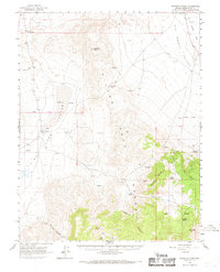
1963 Map of Rhyolite Ridge
USGS Topo · Published 1969About this map
Silver Peak Range dominates this 1960s Esmeralda County landscape, serving as a high divide between Fish Lake Valley to the west and the expansive Big Smoky Valley to the northeast. The map documents an arid environment defined by vital water sources like Valcalda Spring, Minnesota Spring, and Gap Spring. Evidence of early transportation and commerce is scattered throughout the terrain, from the Old Railroad Grade in the northeast to the remote The Crossing and nearby Landing Strips on the valley floor. The placement of numerous Prospects and a primary Mine along Black Canyon suggests a period of active mineral exploration. Topographical landmarks such as Emigrant Peak and Emigrant Pass anchor the central portion of the range, while the distinctive volcanic formations of Rhyolite Ridge rise toward the southeast.
Find a feature on this map
41 named features on this map. Tap any name to fly to it.
Don’t see what you’re looking for? This feature index may not catch every label — zoom into the map to look around manually.
Map Details
Editions of this 1963 Rhyolite Ridge Map
2 editions found
Other maps of this area

1898 · Silver Peak
USGS Topo · 1:125,000

1900 · Silver Peak
USGS Topo · 1:125,000

1907 · Tonopah
USGS Topo · 1:250,000

1908 · Lida
USGS Topo · 1:250,000

1908 · Tonopah
USGS Topo · 1:250,000

1909 · Hawthorne
USGS Topo · 1:250,000

1911 · Hawthorne
USGS Topo · 1:250,000

1913 · Lida
USGS Topo · 1:250,000

1915 · Hawthorne
USGS Topo · 1:250,000

1917 · White Mountain
USGS Topo · 1:125,000