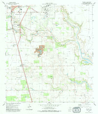
1979 Map of Ricardo
USGS Topo · Published 1979About this map
Kingsville and the smaller community of Ricardo anchor this South Texas landscape in the late 1970s, defined by a mix of military installations and expansive ranching infrastructure. The Naval Air Station dominates the northern portion of the sheet, while the Missouri Pacific railroad corridor provides the primary north-south transportation spine. The map documents local social hubs and education, featuring the Northway Exposition Center, Perez Sch, and Pan American Sch.
Find a feature on this map
27 named features on this map. Tap any name to fly to it.
Don’t see what you’re looking for? This feature index may not catch every label — zoom into the map to look around manually.
Map Details
Editions of this 1979 Ricardo Map
This is the sole edition of this map. No revisions or reprints were ever made.
Other maps of this area

1924 · Petronilla
USGS Topo · 1:62,500

1928 · Sarita
USGS Topo · 1:125,000

1950 · Corpus Christi
USGS Topo · 1:250,000

1952 · Riviera Beach
USGS Topo · 1:24,000

1952 · Riviera Beach NW
USGS Topo · 1:24,000

1952 · Riviera Beach
USGS Topo · 1:62,500

1954 · Kingsville
USGS Topo · 1:62,500

1954 · Petronila
USGS Topo · 1:62,500

1954 · Riviera
USGS Topo · 1:62,500

1956 · Corpus Christi
USGS Topo · 1:250,000