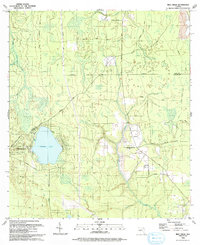
1993 Map of Rice Creek
USGS Topo · Published 1993About this map
Georges Lake and its surrounding wetlands define the landscape of this Putnam County region in the early 1990s. The settlement of Harlem is a primary focal point, served by a network of local roads including Harlem Cem Rd and Bardin Road. Significant for genealogical research, the area contains multiple burial sites such as Union Grove Cem, Harlem Cem, and Providence Cem. The ecclesiastical life of the community is anchored by First Baptist Ch near the lake and Providence Ch further east. The topography is intricately carved by water, with Rice Creek and Etonia Creek draining the lowlands. Extensive four-wheel-drive trails and property boundaries like East Boundary Road reflect the rural, managed character of the terrain along the border of Clay and Putnam counties.
Find a feature on this map
39 named features on this map. Tap any name to fly to it.
Don’t see what you’re looking for? This feature index may not catch every label — zoom into the map to look around manually.
Map Details
Editions of this 1993 Rice Creek Map
This is the sole edition of this map. No revisions or reprints were ever made.
Other maps of this area

1912 · Palatka
USGS Topo · 1:48,000

1915 · Palatka
USGS Topo · 1:62,500

1915 · Interlachen
USGS Topo · 1:48,000

1916 · Interlachen
USGS Topo · 1:62,500

1942 · Ates Creek
USGS Topo · 1:62,500

1944 · Interlachen
USGS Topo · 1:62,500

1947 · Bostwick
USGS Topo · 1:50,000

1949 · Rice Creek
USGS Topo · 1:24,000

1949 · Bostwick
USGS Topo · 1:24,000

1949 · Green Cove Springs
USGS Topo · 1:24,000