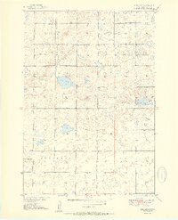
1951 Map of Rice Lake
USGS Topo · Published 1951About this map
Glacial potholes and shallow basins dominate this corner of Hyde County in the early 1950s, a landscape defined by its scattered water bodies and rural township divisions. The map highlights the township lines of Union, Bane, Illinois, and Eden, showing a sparsely populated agricultural region where local education was still centered around small country schoolhouses. These landmarks, including Rice Lake Sch, Money Sch, and North Illinois Sch, represent the social anchors for farming families before the era of district consolidation.
Find a feature on this map
11 named features on this map. Tap any name to fly to it.
Don’t see what you’re looking for? This feature index may not catch every label — zoom into the map to look around manually.
Map Details
Editions of this 1951 Rice Lake Map
2 editions found
Other maps of this area

1949 · Mitchell Lake
USGS Topo · 1:24,000

1950 · Highmore NE
USGS Topo · 1:24,000

1950 · Mitchell Lake
USGS Topo · 1:24,000

1950 · Rezac Lake NE
USGS Topo · 1:24,000

1950 · Rezac Lake
USGS Topo · 1:24,000

1951 · Rezac Lake NE
USGS Topo · 1:24,000

1951 · Rice Lake
USGS Topo · 1:24,000

1951 · Rezac Lake
USGS Topo · 1:24,000

1951 · Rezac Lake NW
USGS Topo · 1:24,000

1953 · Huron
USGS Topo · 1:250,000