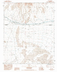
1983 Map of Rice
USGS Topo · Published 1986About this map
Rice stands as the primary settlement in this arid landscape, situated at the junction of the Atchison Topeka and Santa Fe railroad and local desert routes. The 1983 survey illustrates a landscape defined by significant water infrastructure, notably the Colorado River Aqueduct which traverses the northern section with an intricate system of dikes, siphons, and a Drum Gate. This infrastructure reflects the engineering required to move water across the expansive Rice Valley.
Find a feature on this map
14 named features on this map. Tap any name to fly to it.
Don’t see what you’re looking for? This feature index may not catch every label — zoom into the map to look around manually.
Map Details
Editions of this 1983 Rice Map
2 editions found
Other maps of this area

1942 · Blythe
USGS Topo · 1:250,000

1943 · Vidal
USGS Topo · 1:62,500

1945 · Big Maria Mtns
USGS Topo · 1:62,500

1945 · Midland
USGS Topo · 1:62,500

1949 · Vidal
USGS Topo · 1:62,500

1950 · Vidal
USGS Topo · 1:62,500

1951 · Big Maria Mts
USGS Topo · 1:62,500

1952 · Midland
USGS Topo · 1:62,500

1954 · Salton Sea
USGS Topo · 1:250,000

1954 · Needles
USGS Topo · 1:250,000