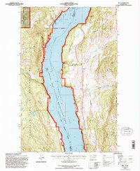
1992 Map of Rice
USGS Topo · Published 1996About this map
The Columbia River corridor dominates this landscape, transformed by the rising waters of Franklin D Roosevelt Lake within the Coulee Dam National Recreation Area. On the eastern bank, the small settlement of Rice and the Cem nearby sit below the prominent Chalk Grade Flat, while the western shore is defined by the Colville Indian Reservation and the steep slopes of Staehly Mountain. This geography reflects a post-dam era where traditional riverside life was pushed to higher ground. Local family history and industrial footprints are evident at Staehly Ranch and the Staehly Mine, tucked into the western canyons. The map also identifies the site of Cuba and features of interest for exploration, such as Barnaby Island and the secluded Rotter Bay, alongside varied drainages like Flour Mill Creek and Quillisascut Creek.
Find a feature on this map
40 named features on this map. Tap any name to fly to it.
Don’t see what you’re looking for? This feature index may not catch every label — zoom into the map to look around manually.
Map Details
Editions of this 1992 Rice Map
This is the sole edition of this map. No revisions or reprints were ever made.
Other maps of this area

1936 · Marcus
USGS Topo · 1:96,000

1942 · Marcus
USGS Topo · 1:125,000

1948 · Sherman Peak
USGS Topo · 1:62,500

1948 · Kettle Falls
USGS Topo · 1:62,500

1950 · Inchelium
USGS Topo · 1:62,500

1951 · Sherman Peak
USGS Topo · 1:62,500

1951 · Kettle Falls
USGS Topo · 1:62,500

1952 · Twin Lakes
USGS Topo · 1:62,500

1954 · Okanogan
USGS Topo · 1:250,000

1958 · Okanogan
USGS Topo · 1:250,000