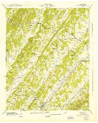
1943 Map of Riceville
USGS Topo · Published 1946About this map
Riceville serves as the primary hub of this 1940s landscape, situated where the Southern railroad and Lee Highway parallel Dry Creek. The area is defined by a series of northeast-trending ridges, including Rogers Ridge and Spring Creek Ridge, which create distinct agricultural valleys like the Oostanaula Valley. This topography shaped a community of small settlements and family farms, evidenced by the high density of rural institutions such as Idlewild Sch, McMahan Ch, and Walnut Grove Ch. Local industry and resource management are marked by the presence of Mouse Creek Mill and several named springs, including Peck Spring and Cate Spring, which were vital for life in the valleys before modern water infrastructure. Genealogists can find numerous family burial grounds, including Horton Cem and Roberts Cem, distributed across the hillsides.
Find a feature on this map
57 named features on this map. Tap any name to fly to it.
Don’t see what you’re looking for? This feature index may not catch every label — zoom into the map to look around manually.
Map Details
Editions of this 1943 Riceville Map
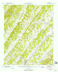
2 editions found
Other maps of this area

1886 · Cleveland
USGS Topo · 1:125,000

1887 · Kingston
USGS Topo · 1:125,000

1891 · Kingston
USGS Topo · 1:125,000

1892 · Cleveland
USGS Topo · 1:125,000

1893 · Kingston
USGS Topo · 1:125,000

1895 · Cleveland
USGS Topo · 1:125,000

1901 · Cleveland
USGS Topo · 1:125,000

1935 · Niota
USGS Topo · 1:24,000

1935 · Calhoun
USGS Topo · 1:24,000

1935 · Athens
USGS Topo · 1:24,000