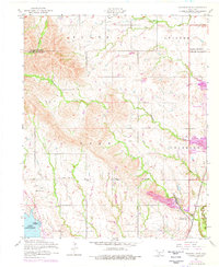
1956 Map of Richards Spur
USGS Topo · Published 1976About this map
The Fort Sill Military Reservation occupies a significant portion of this landscape at the northern edge of Comanche County. Centered around the rugged topography of Chandler and Lake townships, the map reveals a mid-century transition as recreational communities like Edgewater Park and Lakeside Village began to take shape along the shores of Lake Ellsworth. To the south, an abandoned fish hatchery near Lake Lawtonka and a large Quarry near Richards Spur illustrate the shifting economic uses of the land.
Find a feature on this map
21 named features on this map. Tap any name to fly to it.
Don’t see what you’re looking for? This feature index may not catch every label — zoom into the map to look around manually.
Map Details
Editions of this 1956 Richards Spur Map
2 editions found

Other maps of this area

1937 · Cache
USGS Topo · 1:48,000

1942 · Cache
USGS Topo · 1:62,500

1946 · Lawton
USGS Topo · 1:62,500

1949 · Mount Scott
USGS Topo · 1:24,000

1949 · Arbuckle Hill
USGS Topo · 1:24,000

1949 · Elgin
USGS Topo · 1:24,000

1949 · Fort Sill
USGS Topo · 1:24,000

1950 · Saddle Mountain
USGS Topo · 1:62,500

1955 · Lawton
USGS Topo · 1:250,000

1956 · Arbuckle Hill
USGS Topo · 1:24,000