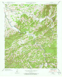
1940 Map of Richardson Cove
USGS Topo · Published 1972About this map
The East Fork Little Pigeon River carves a winding path through this corner of Sevier County, where 1940 field examinations recorded a landscape of ridge-top schools and creek-bottom settlements. This area is characterized by dense clusters of community institutions, including the Smoky Mtn Academy near Pittman Center and numerous small country schools such as Roberta Sch and Laurel Sch. Genealogists will find a wealth of family-named landmarks and cemeteries, from the Ball Cem and Thomas Cem in the northeast to the Williams Cem near Richardson Cove. The terrain is defined by prominent heights like Bearwallow Mountain and Webb Mountain, which hem in narrow hollows like Maple Hollow. At the southern edge, the boundary of the Great Smoky Mts Nat Park indicates the transition from settled agricultural land to protected wilderness.
Find a feature on this map
109 named features on this map. Tap any name to fly to it.
Don’t see what you’re looking for? This feature index may not catch every label — zoom into the map to look around manually.
Map Details
Editions of this 1940 Richardson Cove Map
4 editions found
Other maps of this area

1886 · Knoxville
USGS Topo · 1:125,000

1892 · Knoxville
USGS Topo · 1:125,000

1893 · Mt Guyot
USGS Topo · 1:125,000

1894 · Knoxville
USGS Topo · 1:125,000

1895 · Knoxville
USGS Topo · 1:125,000

1901 · Knoxville
USGS Topo · 1:125,000

1912 · Mt Guyot
USGS Topo · 1:125,000

1935 · English Mountain
USGS Topo · 1:48,000

1935 · Clevenger
USGS Topo · 1:24,000

1935 · Jones Cove
USGS Topo · 1:24,000