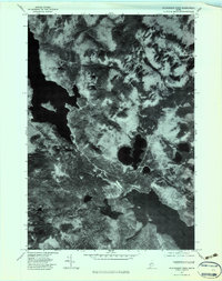
1977 Map of Richardson Pond
USGS Topo · Published 1983About this map
Upper Richardson Lake and the vast waters of Aziscohos Lake dominate this high-contrast orthophotoquad, which captures the remote character of Oxford County in the late 1970s. The imagery reveals the complex shoreline of these major reservoirs and the network of logging roads and trails that traverse the heavily forested topography. This U.S. Geological Survey orthophoto provides a direct photographic record of the landscape's texture, from the shadowed slopes of Deer Mountain to the smaller, secluded waters of Richardson Pond. Between the peaks of Observatory Mountain and Low Aziscohos Mountain, the winding course of Deer Mountain Stream and the basin of Beaver Pond show a landscape defined by water and timber, largely undeveloped except for the essential infrastructure of the regional logging industry.
Find a feature on this map
8 named features on this map. Tap any name to fly to it.
Don’t see what you’re looking for? This feature index may not catch every label — zoom into the map to look around manually.
Map Details
Editions of this 1977 Richardson Pond Map
This is the sole edition of this map. No revisions or reprints were ever made.
Other maps of this area

1927 · Second Lake
USGS Topo · 1:62,500

1930 · Errol
USGS Topo · 1:62,500

1931 · Cupsuptic
USGS Topo · 1:48,000

1932 · Second Lake
USGS Topo · 1:62,500

1934 · Cupsuptic
USGS Topo · 1:62,500

1934 · Errol
USGS Topo · 1:62,500

1935 · Cupsuptic
USGS Topo · 1:62,500

1940 · Oquossoc
USGS Topo · 1:62,500

1942 · Oquossoc
USGS Topo · 1:62,500

1949 · Jackman
USGS Topo · 1:250,000
Featured Places
- Magalloway Plantation, ME
- Lincoln Plantation, ME
- Adamstown Township, ME
- Parkertown Township, ME
- Richardsontown Township, ME