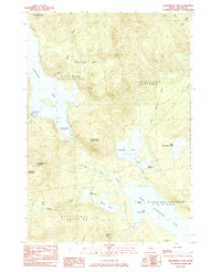
1984 Map of Richardson Pond
USGS Topo · Published 1985About this map
The western Maine wilderness of Oxford County is defined by a massive network of waterways and timberlands in the early 1980s. Aziscohos Lake dominates the western edge of the map, regulated by the Aziscohos Dam and supporting recreational access through the Boat Ramp Campground near Black Brook Cove. This map captures a landscape divided by large geographic townships and plantations, including Lincoln Plantation, Adamstown, and Richardsontown. Notable peaks like Observatory Mountain and Aziscohos Mountain rise between the major lake basins, while smaller interior waters like Richardson Pond and Pepperpot Pond drain through Mill Brook toward the West Arm of Upper Richardson Lake. The topography reflects a remote area primarily managed for timber and seasonal recreation, with numerous logging roads and trails connecting the isolated coves and peaks.
Find a feature on this map
33 named features on this map. Tap any name to fly to it.
Don’t see what you’re looking for? This feature index may not catch every label — zoom into the map to look around manually.
Map Details
Editions of this 1984 Richardson Pond Map
This is the sole edition of this map. No revisions or reprints were ever made.
Other maps of this area

1927 · Second Lake
USGS Topo · 1:62,500

1930 · Errol
USGS Topo · 1:62,500

1931 · Cupsuptic
USGS Topo · 1:48,000

1932 · Second Lake
USGS Topo · 1:62,500

1934 · Cupsuptic
USGS Topo · 1:62,500

1934 · Errol
USGS Topo · 1:62,500

1935 · Cupsuptic
USGS Topo · 1:62,500

1940 · Oquossoc
USGS Topo · 1:62,500

1942 · Oquossoc
USGS Topo · 1:62,500

1949 · Jackman
USGS Topo · 1:250,000
Featured Places
- Magalloway Plantation, ME
- Lincoln Plantation, ME
- Adamstown Township, ME
- Parkertown Township, ME
- Richardsontown Township, ME