1951 Map of Richardson Springs
USGS Topo · Published 1970About this map
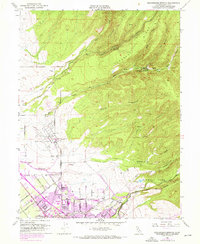
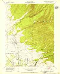
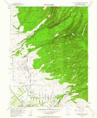
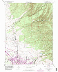
Richardson Springs serves as a focal point north of the growing city of Chico, showing the transition from agricultural valley lands to the rising Cohasset Ridge. The landscape is defined by the drainage patterns of Mud Creek, Sycamore Creek, and Rock Creek, which flow southwest toward the Sacramento Valley. The 1969 revisions, indicated in purple, highlight significant urban expansion in the southern portion of the map, particularly residential development along Lindo Channel and around Marigold Sch.
Find a feature on this map
56 named features on this map. Tap any name to fly to it.
Don’t see what you’re looking for? This feature index may not catch every label — zoom into the map to look around manually.
Map Details
Editions of this 1951 Richardson Springs Map
5 editions found
Historical Maps of Chico Through Time
112 maps found

1911 Landlow
Butte County, CA

1912 Chico Landing
Butte County, CA

1912 Clear Creek
Butte County, CA

1912 Dry Creek
Butte County, CA

1912 Keefers
Butte County, CA

1912 Nelson
Butte County, CA

1912 Newhard
Butte County, CA

1912 Pennington
Butte County, CA

1942 Butte Sink
Butte County, CA

1944 Richardson Springs
Butte County, CA

1947 Bidwell Bar
Butte County, CA

1947 Brush Creek
Butte County, CA

1948 Big Bend Mtn
Butte County, CA

1948 Cascade
Butte County, CA

1948 Las Plumas
Butte County, CA

1948 Llano Seco
Butte County, CA

1948 Nelson
Butte County, CA

1948 Shippee
Butte County, CA

1949 Brush Creek
Butte County, CA

1949 Ord Ferry
Butte County, CA

1950 Bidwell Bar
Butte County, CA

1950 Cascade
Butte County, CA

1950 Las Plumas
Butte County, CA

1950 Llano Seco
Butte County, CA

1950 Nelson
Butte County, CA

1950 Ord Ferry
Butte County, CA

1950 Shippee
Butte County, CA

1951 Hamlin Canyon
Butte County, CA

1951 Richardson Springs
Butte County, CA

1952 Richardson Springs
Butte County, CA

1952 West of Biggs
Butte County, CA

1954 Butte City
Butte County, CA

1954 Pennington
Butte County, CA

1956 Brush Creek
Butte County, CA

1957 Pulga
Butte County, CA

1970 Brush Creek
Butte County, CA

1970 Oroville Dam
Butte County, CA

1979 Kimshew Point
Butte County, CA

1979 Pulga
Butte County, CA

1980 Paradise East
Butte County, CA

1980 Paradise West
Butte County, CA

1991 Jonesville
Butte County, CA

1994 Brush Creek
Butte County, CA

1994 Cascade
Butte County, CA

1994 Paradise East
Butte County, CA

1994 Pulga
Butte County, CA

1995 Jonesville
Butte County, CA

1995 Kimshew Point
Butte County, CA

2012 Brush Creek
Butte County, CA

2012 Cascade
Butte County, CA

2012 Hamlin Canyon
Butte County, CA

2012 Jonesville
Butte County, CA

2012 Kimshew Point
Butte County, CA

2012 Llano Seco
Butte County, CA

2012 Nelson
Butte County, CA

2012 Ord Ferry
Butte County, CA

2012 Oroville Dam
Butte County, CA

2012 Paradise East
Butte County, CA

2012 Paradise West
Butte County, CA

2012 Pennington
Butte County, CA

2012 Pulga
Butte County, CA

2012 Richardson Springs
Butte County, CA

2012 Shippee
Butte County, CA

2012 West of Biggs
Butte County, CA

2015 Brush Creek
Butte County, CA

2015 Cascade
Butte County, CA

2015 Hamlin Canyon
Butte County, CA

2015 Jonesville
Butte County, CA

2015 Kimshew Point
Butte County, CA

2015 Llano Seco
Butte County, CA

2015 Nelson
Butte County, CA

2015 Ord Ferry
Butte County, CA

2015 Oroville Dam
Butte County, CA

2015 Paradise East
Butte County, CA

2015 Paradise West
Butte County, CA

2015 Pennington
Butte County, CA

2015 Pulga
Butte County, CA

2015 Richardson Springs
Butte County, CA

2015 Shippee
Butte County, CA

2015 West of Biggs
Butte County, CA

2018 Brush Creek
Butte County, CA

2018 Cascade
Butte County, CA

2018 Hamlin Canyon
Butte County, CA

2018 Jonesville
Butte County, CA

2018 Kimshew Point
Butte County, CA

2018 Llano Seco
Butte County, CA

2018 Nelson
Butte County, CA

2018 Ord Ferry
Butte County, CA

2018 Oroville Dam
Butte County, CA

2018 Paradise East
Butte County, CA

2018 Paradise West
Butte County, CA

2018 Pennington
Butte County, CA

2018 Pulga
Butte County, CA

2018 Richardson Springs
Butte County, CA

2018 Shippee
Butte County, CA

2018 West of Biggs
Butte County, CA

2021 Hamlin Canyon
Butte County, CA

2021 Jonesville
Butte County, CA

2021 Nelson
Butte County, CA

2021 Ord Ferry
Butte County, CA

2021 Oroville Dam
Butte County, CA

2021 Paradise West
Butte County, CA

2021 Pennington
Butte County, CA

2021 Shippee
Butte County, CA

2021 West of Biggs
Butte County, CA

2022 Brush Creek
Butte County, CA

2022 Cascade
Butte County, CA

2022 Kimshew Point
Butte County, CA

2022 Llano Seco
Butte County, CA

2022 Paradise East
Butte County, CA

2022 Pulga
Butte County, CA

2022 Richardson Springs
Butte County, CA