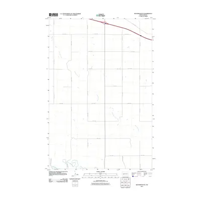
2011 Map of Richardton SE
USGS Topo · Published 2011About this map
Government Creek dominates the landscape of this portion of Stark County, its meandering path carving through the prairie as it drains toward the south. The creek finally meets the Heart River at the southern edge of the quadrangle, a significant drainage for the region. This 2011 survey illustrates a highly organized township-and-range section system, defined by a rigid grid of local routes such as 91st Ave Sw and 38th St Sw. In the northeast corner, County Rd 139 cuts across the cardinal grid, reflecting the influence of regional connectivity over the local agricultural boundaries. The lack of concentrated town sites emphasizes the area's rural character, where the primary infrastructure consists of access roads for the surrounding ranching or farming operations.
Find a feature on this map
16 named features on this map. Tap any name to fly to it.
Don’t see what you’re looking for? This feature index may not catch every label — zoom into the map to look around manually.
Map Details
Editions of this 2011 Richardton SE Map
This is the sole edition of this map. No revisions or reprints were ever made.
Other maps of this area

1953 · Dickinson
USGS Topo · 1:250,000

1957 · Dickinson
USGS Topo · 1:250,000

1960 · White Butte NW
USGS Topo · 1:24,000

1960 · Clark Butte NW
USGS Topo · 1:24,000

1960 · White Butte NE
USGS Topo · 1:24,000

1973 · Bratburg Butte
USGS Topo · 1:24,000

1973 · Taylor
USGS Topo · 1:24,000

1973 · Richardton SE
USGS Topo · 1:24,000
1973 · Richardton
USGS Topo · 1:24,000
1973 · Antelope
USGS Topo · 1:24,000