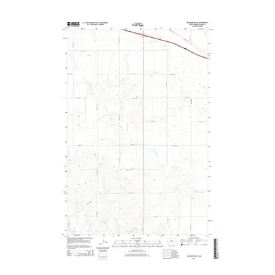
2014 Map of Richardton SE
USGS Topo · Published 2014About this map
The Heart River meanders across the southern portion of this Stark County landscape, defining the local drainage pattern alongside Government Cr, which cuts through the central section of the quadrangle. This 2014 survey captures a rural North Dakota environment organized by the Public Land Survey System, where a rigid grid of section-line roads like 90th Ave SW and 38th St SW facilitates travel across the high plains. In the northeast corner, Highway 10 provides a primary east-west corridor, mirroring the path of the interstate just to its north. The map documents a landscape characterized by low-relief terrain and small seasonal watercourses, showing the intersection of traditional agricultural transportation networks and modern infrastructure in the western reaches of the state.
Find a feature on this map
16 named features on this map. Tap any name to fly to it.
Don’t see what you’re looking for? This feature index may not catch every label — zoom into the map to look around manually.
Map Details
Editions of this 2014 Richardton SE Map
This is the sole edition of this map. No revisions or reprints were ever made.
Other maps of this area

1953 · Dickinson
USGS Topo · 1:250,000

1957 · Dickinson
USGS Topo · 1:250,000

1960 · White Butte NW
USGS Topo · 1:24,000

1960 · Clark Butte NW
USGS Topo · 1:24,000

1960 · White Butte NE
USGS Topo · 1:24,000

1973 · Bratburg Butte
USGS Topo · 1:24,000

1973 · Taylor
USGS Topo · 1:24,000

1973 · Richardton SE
USGS Topo · 1:24,000
1973 · Richardton
USGS Topo · 1:24,000
1973 · Antelope
USGS Topo · 1:24,000