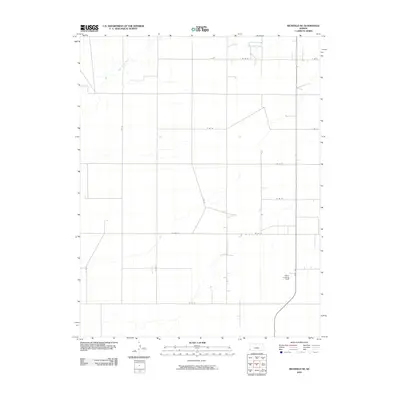
2010 Map of Richfield NE
USGS Topo · Published 2010About this map
Sand Arroyo Creek meanders through this agricultural landscape in Stanton County, defining the drainage patterns of an area dominated by a precise section-line road grid. The map illustrates a rural environment shaped by the intersection of north-south routes like S Rd Q and east-west thoroughfares such as W Rd 25. This intersection of natural hydrology and man-made geography is a characteristic of the High Plains, where watercourses often dictate the placement of earlier trails before being superseded by the rigid geometry of county roads. A specific point of interest for local historians and aviation researchers is Johns Landing Field, situated along State Hwy 27. This small landing strip highlights the importance of private aviation in maintaining connectivity across the expansive distances of Western Kansas, serving as a vital link for the surrounding farming community.
Find a feature on this map
17 named features on this map. Tap any name to fly to it.
Don’t see what you’re looking for? This feature index may not catch every label — zoom into the map to look around manually.
Map Details
Editions of this 2010 Richfield NE Map
This is the sole edition of this map. No revisions or reprints were ever made.
Other maps of this area

1900 · Syracuse
USGS Topo · 1:125,000

1920 · Syracuse
USGS Topo · 1:125,000

1955 · Dodge City
USGS Topo · 1:250,000

1958 · Dodge City
USGS Topo · 1:250,000

1959 · Dodge City
USGS Topo · 1:250,000

1959 · Big Bow SW
USGS Topo · 1:24,000

1973 · Richfield NW
USGS Topo · 1:24,000

1973 · Shore Airport SW
USGS Topo · 1:24,000

1973 · Shore Airport
USGS Topo · 1:24,000
1973 · Manter
USGS Topo · 1:24,000