
1973 Map of Richfield NE
USGS Topo · Published 1975About this map
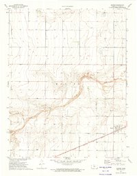
The High Plains landscape of Southwest Kansas is defined here by the wide, winding course of Sand Arroyo Creek, which cuts across the northern section of the terrain. This 1973 survey illustrates the sparsely settled nature of the region, where the primary human footprint consists of section lines and energy infrastructure. The small settlement of Cleaves stands as a focal point in the western half, while the presence of several Gas Wells and individual Wells indicates the importance of subsurface resources in this arid environment. Near the southern border, the Stanton and Morton County line marks a political boundary in an otherwise open stretch of prairie. Of particular interest to aviation history is the Johns Landing Field in the southeast, a small airstrip that speaks to the necessity of private flight in connecting these isolated agricultural and industrial outposts.
Find a feature on this map
10 named features on this map. Tap any name to fly to it.
Don’t see what you’re looking for? This feature index may not catch every label — zoom into the map to look around manually.
Map Details
Editions of this 1973 Richfield NE Map
This is the sole edition of this map. No revisions or reprints were ever made.
Other maps of this area

1900 · Syracuse
USGS Topo · 1:125,000

1920 · Syracuse
USGS Topo · 1:125,000

1955 · Dodge City
USGS Topo · 1:250,000

1958 · Dodge City
USGS Topo · 1:250,000

1959 · Dodge City
USGS Topo · 1:250,000

1959 · Big Bow SW
USGS Topo · 1:24,000

1973 · Richfield NW
USGS Topo · 1:24,000

1973 · Shore Airport SW
USGS Topo · 1:24,000

1973 · Shore Airport
USGS Topo · 1:24,000
1973 · Manter
USGS Topo · 1:24,000