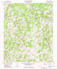
1981 Map of Richfield
USGS Topo · Published 1981About this map
Misenheimer and the Pfeiffer College campus anchor the northern landscape of this Stanly County survey, where the Norfolk Southern line cuts through a countryside defined by small rural centers and historic congregations. The settlement of Richfield marks a primary junction, while smaller hamlets like Millingport, Pauls Crossing, and Finger are connected by a network of roads crossing Long Creek, Buffalo Creek, and Big Bear Creek. Local social and family history is centered on numerous country churches including Bethlehem Ch, Mattons Grove Ch, and Salem Ch. The presence of a Quarry and the Bear Creek Airport near the Cabarrus Co line highlights the mix of industrial extraction and regional infrastructure supporting these Piedmont communities during the late 1970s.
Find a feature on this map
29 named features on this map. Tap any name to fly to it.
Don’t see what you’re looking for? This feature index may not catch every label — zoom into the map to look around manually.
Map Details
Editions of this 1981 Richfield Map
2 editions found
Other maps of this area

1949 · High Rock
USGS Topo · 1:24,000

1953 · Charlotte
USGS Topo · 1:250,000

1954 · Charlotte
USGS Topo · 1:250,000

1957 · Mount Pleasant
USGS Topo · 1:62,500

1957 · Albemarle
USGS Topo · 1:62,500

1957 · Denton
USGS Topo · 1:62,500

1960 · Charlotte
USGS Topo · 1:250,000

1962 · Charlotte
USGS Topo · 1:250,000
1962 · Gold Hill
USGS Topo · 1:24,000
1962 · Rockwell
USGS Topo · 1:24,000