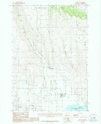
1987 Map of Richland
USGS Topo · Published 1987About this map
The lowlands of Eagle Valley define this portion of Baker County, where irrigation infrastructure supports the agricultural settlements of Richland and New Bridge. The landscape is shaped by the complex water management systems of the late twentieth century, including the Pine Valley Ditch and Newt Young Ditch, which divert water from mountain-fed streams to the valley floor. To the north, the terrain rises into the timbered slopes of the Wallowa-Whitman National Forest, marked by numerous drainages such as Summit Creek and Barnard Creek. In the south, the Powder River flows into the Brownlee Reservoir, a major geographic feature resulting from mid-century hydroelectric development. Small-scale industrial and municipal features, including a Mill Pond and Sewage Disposal Ponds, indicate the localized utility and industry of these rural Oregon communities during the 1980s.
Find a feature on this map
19 named features on this map. Tap any name to fly to it.
Don’t see what you’re looking for? This feature index may not catch every label — zoom into the map to look around manually.
Map Details
Editions of this 1987 Richland Map
This is the sole edition of this map. No revisions or reprints were ever made.
Other maps of this area

1915 · Pine
USGS Topo · 1:125,000

1955 · Baker
USGS Topo · 1:250,000

1957 · Halfway
USGS Topo · 1:62,500

1957 · Sparta
USGS Topo · 1:62,500

1957 · Durkee
USGS Topo · 1:62,500

1957 · Mineral
USGS Topo · 1:62,500

1959 · Baker
USGS Topo · 1:250,000

1981 · Baker
USGS Topo · 1:100,000
1987 · Sturgill Creek
USGS Topo · 1:24,000
1987 · Jimtown
USGS Topo · 1:24,000