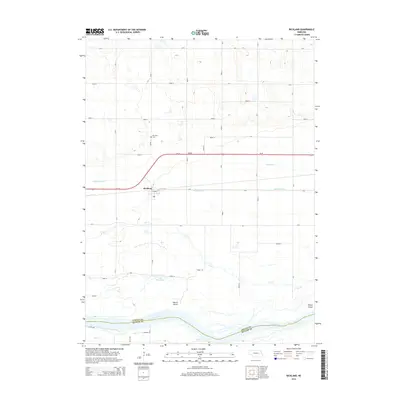
2014 Map of Richland
USGS Topo · Published 2014About this map
Richland serves as the central hub of this agricultural landscape in eastern Nebraska, situated along the corridor of Us-30 and E Front St. The settlement is defined by its proximity to the vast braided channels of the Platte River, which forms the boundary between Colfax and Butler counties. This 2014 survey reveals a highly managed hydraulic landscape where natural waterways like Lost Cr and Deer Cr are supplemented by man-made irrigation infrastructure, including the Barnholdt Ditch and Shonka Ditch. For those researching local roots, the Richland Cem stands to the north of town, while the river valley features prominent landforms like Hewitt Island and Tomek Island. The area around Lake McAllister further illustrates the low-lying, water-rich nature of the terrain between the primary riverbed and the developed uplands.
Find a feature on this map
29 named features on this map. Tap any name to fly to it.
Don’t see what you’re looking for? This feature index may not catch every label — zoom into the map to look around manually.
Map Details
Editions of this 2014 Richland Map
This is the sole edition of this map. No revisions or reprints were ever made.
Other maps of this area

1899 · David City
USGS Topo · 1:125,000

1955 · Fremont
USGS Topo · 1:250,000

1957 · Fremont
USGS Topo · 1:250,000

1958 · Fremont
USGS Topo · 1:250,000

1958 · Columbus SE
USGS Topo · 1:24,000

1958 · Columbus
USGS Topo · 1:24,000

1966 · Clarkson SW
USGS Topo · 1:24,000

1966 · Humphrey SE
USGS Topo · 1:24,000
1966 · Clarkson SE
USGS Topo · 1:24,000
1968 · David City West
USGS Topo · 1:24,000