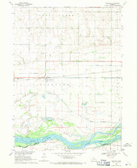
1968 Map of Richland
USGS Topo · Published 1971About this map
Richland sits as the central hub of this agrarian landscape, positioned directly along the Union Pacific railroad line. The settlement patterns of the late 1960s are clearly visible, showing a mix of established infrastructure and the essential water management systems required for Nebraska farming. The map traces the intricate paths of Shell Creek, Lost Creek, and artificial waterways like the Shonka Ditch and Barnholdt Ditch as they drain toward the wide, braided channels of the Platte River.
Find a feature on this map
23 named features on this map. Tap any name to fly to it.
Don’t see what you’re looking for? This feature index may not catch every label — zoom into the map to look around manually.
Map Details
Editions of this 1968 Richland Map
This is the sole edition of this map. No revisions or reprints were ever made.
Other maps of this area

1899 · David City
USGS Topo · 1:125,000

1955 · Fremont
USGS Topo · 1:250,000

1957 · Fremont
USGS Topo · 1:250,000

1958 · Fremont
USGS Topo · 1:250,000

1958 · Columbus SE
USGS Topo · 1:24,000

1958 · Columbus
USGS Topo · 1:24,000

1966 · Clarkson SW
USGS Topo · 1:24,000

1966 · Humphrey SE
USGS Topo · 1:24,000
1966 · Clarkson SE
USGS Topo · 1:24,000
1968 · David City West
USGS Topo · 1:24,000