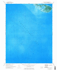
1973 Map of Richland Point
USGS Topo · Published 1975About this map
Lower Hooper Island and Middle Hooper Island dominate this orthophotomap, which uses aerial photography from 1972 to reveal the complex interplay between land and water in Dorchester County. The settlement of Applegarth sits near the southern end of the lower island, surrounded by numerous aquatic features such as Westward Cr and Nancys Pt. The photography provides a unique look at the shoreline's composition, highlighting the narrow passage of The Thorofare which separates the island masses and connects Honga River with the broader Chesapeake Bay.
Find a feature on this map
24 named features on this map. Tap any name to fly to it.
Don’t see what you’re looking for? This feature index may not catch every label — zoom into the map to look around manually.
Map Details
Editions of this 1973 Richland Point Map
This is the sole edition of this map. No revisions or reprints were ever made.
Other maps of this area

1892 · Drum Point
USGS Topo · 1:62,500

1894 · Point Lookout
USGS Topo · 1:62,500

1898 · St. Marys
USGS Topo · 1:125,000

1901 · Drum Point
USGS Topo · 1:62,500

1903 · Bloodsworth Island
USGS Topo · 1:62,500

1905 · Crapo
USGS Topo · 1:62,500

1905 · Drum Point
USGS Topo · 1:62,500

1906 · St. Marys
USGS Topo · 1:125,000

1912 · Point Lookout
USGS Topo · 1:62,500

1937 · Point Lookout
USGS Topo · 1:62,500