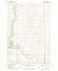
1970 Map of Richmond
USGS Topo · Published 1973About this map
Richmond Lake dominates this Brown County landscape, with its regulated shoreline supporting the Richmond Lake State Recreation Area and specialized local sites like the County Youth Camp and a Public Use Area. The map reveals a transition in the local infrastructure during the late 1960s and early 1970s, clearly tracing an Old RR Grade that cuts across the prairie, reflecting the shift away from rail transport in this rural region. The small settlement of Richmond sits near the southwestern reach of the lake, while Foot Creek winds through the lower sections of the quadrangle.
Find a feature on this map
17 named features on this map. Tap any name to fly to it.
Don’t see what you’re looking for? This feature index may not catch every label — zoom into the map to look around manually.
Map Details
Editions of this 1970 Richmond Map
This is the sole edition of this map. No revisions or reprints were ever made.
Other maps of this area

1894 · Columbia
USGS Topo · 1:62,500

1895 · Aberdeen
USGS Topo · 1:125,000

1896 · Columbia
USGS Topo · 1:125,000

1899 · Ellendale
USGS Topo · 1:125,000

1899 · Northville
USGS Topo · 1:125,000

1952 · Ordway
USGS Topo · 1:24,000

1952 · Westport
USGS Topo · 1:24,000

1952 · Richmond NE
USGS Topo · 1:24,000

1954 · Aberdeen
USGS Topo · 1:250,000

1956 · Aberdeen
USGS Topo · 1:250,000
Featured Places
- Richmond Heights, SD
- Aberdeen Township, SD
- Carlisle Township, SD
- Mercier Township, SD
- Fisher Estates, SD