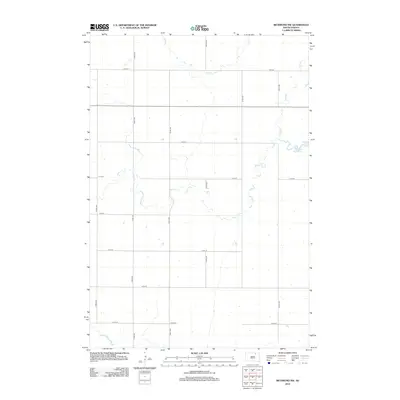
2012 Map of Richmond NW
USGS Topo · Published 2012About this map
Willow Creek Lake serves as a primary hydrological focal point in this portion of Brown County, South Dakota. This section of the James River Valley landscape is defined by the wandering path of Willow Cr and the intermittent drainage of Dry Run, which navigate a strictly regulated section-line road grid. The map reveals a deeply rural character where transportation is almost exclusively oriented along numbered corridors like 375th Ave and 114th St. This 2012 survey by the U.S. Geological Survey illustrates the persistence of the Homestead Act's legacy, with land divisions and access roads following the precise geometric patterns of the Public Land Survey System. The absence of concentrated town centers emphasizes the agricultural nature of Franklyn Township during this period.
Find a feature on this map
16 named features on this map. Tap any name to fly to it.
Don’t see what you’re looking for? This feature index may not catch every label — zoom into the map to look around manually.
Map Details
Editions of this 2012 Richmond NW Map
This is the sole edition of this map. No revisions or reprints were ever made.
Other maps of this area

1894 · Ellendale
USGS Topo · 1:62,500

1899 · Ellendale
USGS Topo · 1:125,000

1952 · Richmond NE
USGS Topo · 1:24,000

1953 · Frederick
USGS Topo · 1:24,000

1954 · Aberdeen
USGS Topo · 1:250,000

1956 · Aberdeen
USGS Topo · 1:250,000

1968 · Forbes SE
USGS Topo · 1:24,000
1968 · Frederick SW
USGS Topo · 1:24,000
1970 · Richmond
USGS Topo · 1:24,000

1970 · Wetonka South
USGS Topo · 1:24,000