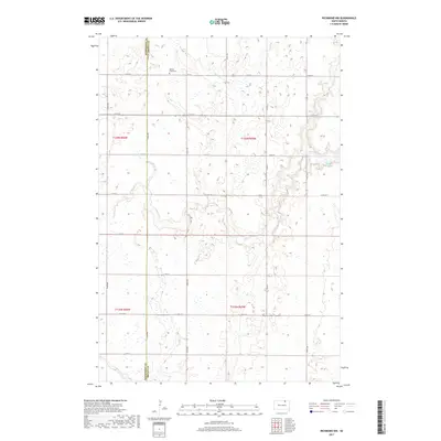
2017 Map of Richmond NW
USGS Topo · Published 2017About this map
The agricultural landscape of Franklyn Township is defined by the winding course of Willow Creek as it meanders across the border of McPherson and Brown Counties. This 2017 survey shows the high density of prairie potholes and wetlands characteristic of the region, interspersed with a precise grid of rural roads like 373rd Ave and 114th St. Central to the area’s local history is the Willow Creek Cemetery, situated near a bend in the creek bed. The hydrology of the area is further marked by Willow Creek Lake and the intermittent drainage of Dry Run, illustrating how the natural topography dictates the placement of farmsteads and field boundaries in this portion of South Dakota.
Find a feature on this map
25 named features on this map. Tap any name to fly to it.
Don’t see what you’re looking for? This feature index may not catch every label — zoom into the map to look around manually.
Map Details
Editions of this 2017 Richmond NW Map
This is the sole edition of this map. No revisions or reprints were ever made.
Other maps of this area

1894 · Ellendale
USGS Topo · 1:62,500

1899 · Ellendale
USGS Topo · 1:125,000

1952 · Richmond NE
USGS Topo · 1:24,000

1953 · Frederick
USGS Topo · 1:24,000

1954 · Aberdeen
USGS Topo · 1:250,000

1956 · Aberdeen
USGS Topo · 1:250,000

1968 · Forbes SE
USGS Topo · 1:24,000
1968 · Frederick SW
USGS Topo · 1:24,000
1970 · Richmond
USGS Topo · 1:24,000

1970 · Wetonka South
USGS Topo · 1:24,000