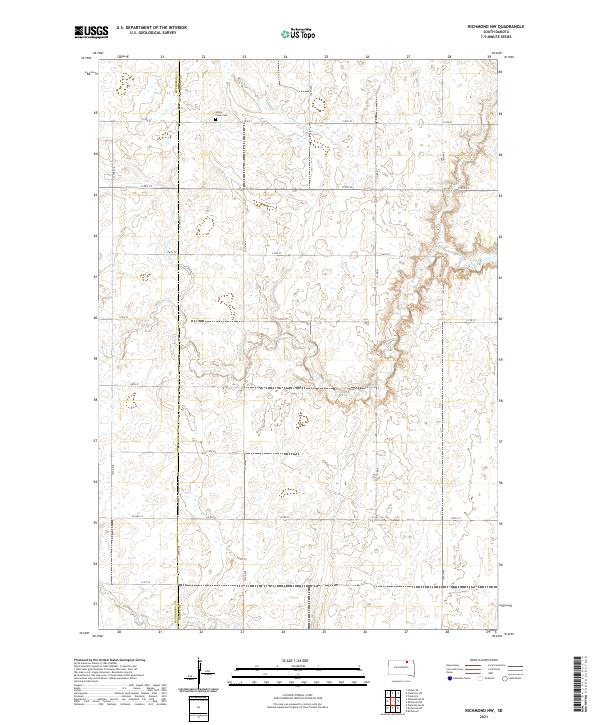
2021 Map of Richmond NW
USGS Topo · Published 2021About this map
Willow Creek Cem sits as a quiet landmark within this rural landscape of northern South Dakota, where the prairie topography is defined by the winding course of Willow Cr and the intermittent drainage of Dry Run. The terrain is partitioned by a strict grid of section roads, including Co Hwy 23 and Co Rd 9, which facilitate travel between the scattered farmsteads of the region. This 2021 survey also documents the administrative boundary between McPherson County and Brown County, which runs vertically through the western portion of the map. The distribution of small wetlands and drainage features reflects the natural hydrology of the Great Plains, showing how modern agricultural land use and county infrastructure have integrated with the existing watercourses.
Find a feature on this map
24 named features on this map. Tap any name to fly to it.
Don’t see what you’re looking for? This feature index may not catch every label — zoom into the map to look around manually.
Map Details
Editions of this 2021 Richmond NW Map
This is the sole edition of this map. No revisions or reprints were ever made.
Other maps of this area

1894 · Ellendale
USGS Topo · 1:62,500

1899 · Ellendale
USGS Topo · 1:125,000

1952 · Richmond NE
USGS Topo · 1:24,000

1953 · Frederick
USGS Topo · 1:24,000

1954 · Aberdeen
USGS Topo · 1:250,000

1956 · Aberdeen
USGS Topo · 1:250,000

1968 · Forbes SE
USGS Topo · 1:24,000
1968 · Frederick SW
USGS Topo · 1:24,000
1970 · Richmond
USGS Topo · 1:24,000

1970 · Wetonka South
USGS Topo · 1:24,000