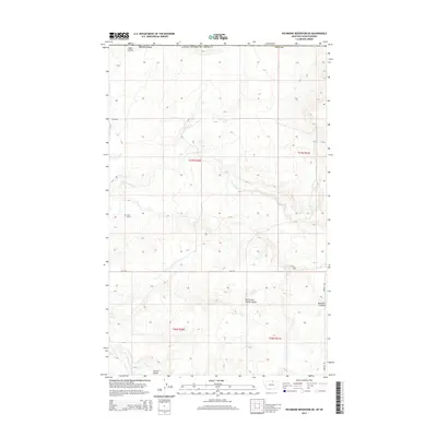
2014 Map of Richmond Reservoir NE
USGS Topo · Published 2014About this map
Dalke Grave provides a poignant genealogical anchor in this remote stretch of the Montana-Saskatchewan borderlands. The landscape is defined by the winding course of the E Fork Battle Cr and a series of distinct drainage patterns including Sand Coulee and North Fork Corral Coulee. These deep incisions in the high plains terrain reveal the hydrological history of the Milk River watershed. Settlement is sparse, with the map showing an infrastructure of section-line roads such as Sage Rd and Frenchy Rd that crisscross the transition between Hill County and Blaine County. The proximity to the international boundary and the presence of names like Bennett Coulee suggest a history of cattle ranching and homesteading in a region where water sources and topographic shelter were vital for survival.
Find a feature on this map
15 named features on this map. Tap any name to fly to it.
Don’t see what you’re looking for? This feature index may not catch every label — zoom into the map to look around manually.
Map Details
Editions of this 2014 Richmond Reservoir NE Map
This is the sole edition of this map. No revisions or reprints were ever made.
Other maps of this area

1912 · Zurich
USGS Topo · 1:125,000

1913 · Cherry Ridge
USGS Topo · 1:125,000

1953 · Havre
USGS Topo · 1:250,000

1957 · Havre
USGS Topo · 1:250,000

1958 · Havre
USGS Topo · 1:250,000

1984 · Richmond Reservoir
USGS Topo · 1:24,000
1984 · Richmond Reservoir SW
USGS Topo · 1:24,000
1984 · Silver Bow Lake
USGS Topo · 1:24,000

1984 · Havre
USGS Topo · 1:100,000
1984 · Irvins Coulee
USGS Topo · 1:24,000