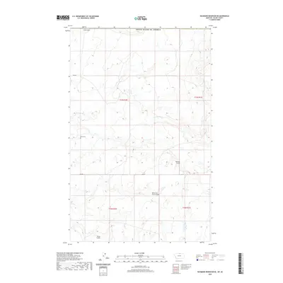
2020 Map of Richmond Reservoir NE
USGS Topo · Published 2020About this map
Dalke Grave stands as a solitary landmark in this northern reach of Blaine County, reflecting the deep personal history embedded in the Montana prairie. This remote landscape is defined by its drainage patterns, with the E Fork Battle Cr cutting through the center of the sheet. The terrain is marked by numerous deep draws including Sand Coulee and Bennett Coulee, which provided natural sheltered corridors in an otherwise exposed high-plains environment. The map details the transition from high ground into lower basins like Corral Coulee and its northern branch, North Fork Corral Coulee. Rural access is maintained via Bagan Rd and Sage Rd, outlining a grid-based land system that persists despite the lack of formal townships or dense settlements in this immediate area of the frontier.
Find a feature on this map
13 named features on this map. Tap any name to fly to it.
Don’t see what you’re looking for? This feature index may not catch every label — zoom into the map to look around manually.
Map Details
Editions of this 2020 Richmond Reservoir NE Map
This is the sole edition of this map. No revisions or reprints were ever made.
Other maps of this area

1912 · Zurich
USGS Topo · 1:125,000

1913 · Cherry Ridge
USGS Topo · 1:125,000

1953 · Havre
USGS Topo · 1:250,000

1957 · Havre
USGS Topo · 1:250,000

1958 · Havre
USGS Topo · 1:250,000

1984 · Richmond Reservoir
USGS Topo · 1:24,000
1984 · Richmond Reservoir SW
USGS Topo · 1:24,000
1984 · Silver Bow Lake
USGS Topo · 1:24,000

1984 · Havre
USGS Topo · 1:100,000
1984 · Irvins Coulee
USGS Topo · 1:24,000