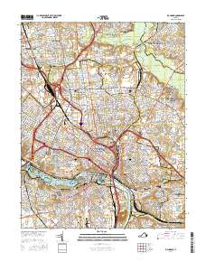
2016 Map of Richmond
USGS Topo · Published 2016About this map
Richmond sits at the fall line of the James River, where the historic city center meets a complex network of neighborhoods and industrial corridors. The city’s profound historical weight is visible through its dense concentration of memorial landscapes, from the Maggie L Walker National Historic Site to the expansive Richmond National Battlefield Park. The map documents a significant genealogical resource, including the prestigious Hollywood Cem, the Emek Sholom Holocaust Cem, and Oakwood Hebrew Cem. Educational institutions like Virginia Commonwealth University and Virginia Union University anchor the urban core, while the Richmond Slave Trail traces a path of deep cultural significance along the riverbanks near Belle Isle and Browns Island. This survey captures the capital city during a period of urban density, showing the fine-grained street grids of Highland Park, Church Hill, and Ginter Park as they transition into the suburban tracts of Henrico County.
Find a feature on this map
81 named features on this map. Tap any name to fly to it.
Don’t see what you’re looking for? This feature index may not catch every label — zoom into the map to look around manually.
Map Details
Editions of this 2016 Richmond Map
This is the sole edition of this map. No revisions or reprints were ever made.
Other maps of this area

1890 · Goochland
USGS Topo · 1:125,000

1892 · Goochland
USGS Topo · 1:125,000

1894 · Bermuda Hundred
USGS Topo · 1:62,500

1894 · Richmond
USGS Topo · 1:62,500

1895 · Richmond
USGS Topo · 1:62,500

1897 · Amelia
USGS Topo · 1:125,000

1934 · Seven Pines
USGS Topo · 1:24,000

1934 · Richmond
USGS Topo · 1:24,000

1936 · Richmond West
USGS Topo · 1:24,000

1936 · Glen Allen
USGS Topo · 1:24,000