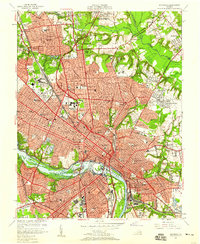
1956 Map of Richmond
USGS Topo · Published 1959About this map
The James River and its rocky islands, including Belle Isle, anchor this mid-century portrait of Virginia’s capital during a period of significant infrastructural change. The 1958 addition of the Richmond-Petersburg Turnpike is clearly visible, slicing through the urban grid and shifting the city's transport logic away from the legacy rail lines of the Southern Railway and Seaboard Air Line Railroad. Beyond the commercial core, the map detail extends to the residential and institutional character of neighborhoods like Ginter Park and Windsor Farms.
Find a feature on this map
72 named features on this map. Tap any name to fly to it.
Don’t see what you’re looking for? This feature index may not catch every label — zoom into the map to look around manually.
Map Details
Editions of this 1956 Richmond Map
This is the sole edition of this map. No revisions or reprints were ever made.
Other maps of this area

1890 · Goochland
USGS Topo · 1:125,000

1892 · Goochland
USGS Topo · 1:125,000

1894 · Bermuda Hundred
USGS Topo · 1:62,500

1894 · Richmond
USGS Topo · 1:62,500

1895 · Richmond
USGS Topo · 1:62,500

1897 · Amelia
USGS Topo · 1:125,000

1934 · Seven Pines
USGS Topo · 1:24,000

1934 · Richmond
USGS Topo · 1:24,000

1936 · Richmond West
USGS Topo · 1:24,000

1936 · Glen Allen
USGS Topo · 1:24,000