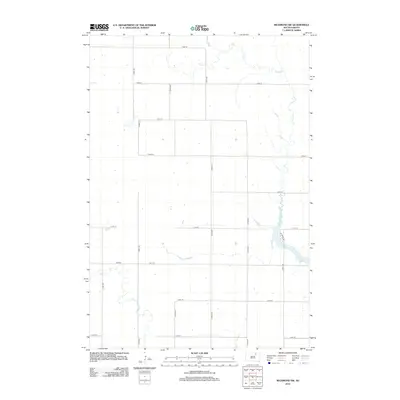
2012 Map of Richmond SW
USGS Topo · Published 2012About this map
Richmond Lake anchors the southeastern corner of this rural landscape in Brown County, South Dakota, where the water is bridged by W Bridge Rd. This 2012 survey illustrates the systematic section-line road network that defines the region's agricultural character, with long, straight thoroughfares like 122nd St and 373rd Ave carving the prairie into distinct parcels. The hydrology of the area is shaped by the meandering courses of Snake Cr in the southwest and Foot Cr in the north, both of which cut through the grid of gravel and dirt roads. The landscape remains largely open, punctuated by isolated farmsteads and the occasional utility structure, reflecting a modern era of high-efficiency farming where the vast majority of the land is dedicated to field crops and grazing.
Find a feature on this map
19 named features on this map. Tap any name to fly to it.
Don’t see what you’re looking for? This feature index may not catch every label — zoom into the map to look around manually.
Map Details
Editions of this 2012 Richmond SW Map
This is the sole edition of this map. No revisions or reprints were ever made.
Other maps of this area

1899 · Ellendale
USGS Topo · 1:125,000

1899 · Northville
USGS Topo · 1:125,000

1952 · Richmond NE
USGS Topo · 1:24,000

1954 · Aberdeen
USGS Topo · 1:250,000

1956 · Aberdeen
USGS Topo · 1:250,000

1960 · Aberdeen West
USGS Topo · 1:24,000

1970 · Lake Parmley
USGS Topo · 1:24,000
1970 · Richmond
USGS Topo · 1:24,000

1970 · Wetonka South
USGS Topo · 1:24,000
1970 · Richmond SW
USGS Topo · 1:24,000