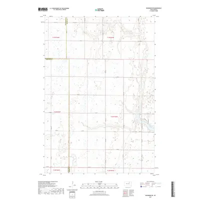
2017 Map of Richmond SW
USGS Topo · Published 2017About this map
Richmond Lake serves as the primary hydrological focus for this portion of the northern plains, where the convergence of Snake Cr and Foot Cr shapes the prairie landscape. The area is defined by a rigorous section-line road network, including Co Hwy 18 and Co Rd 11, which reflects the enduring influence of the Public Land Survey System on South Dakota's settlement patterns. This particular region spans the triple junction of Brown, Edmunds, and McPherson counties, a significant point of interest for researchers tracing administrative and property boundaries. While the terrain is predominantly open, the residential and recreational development near the shoreline is evidenced by local thoroughfares such as Richmond Dr, W Bridge Rd, and Richmond Ln, indicating the lake's importance as a local community hub.
Find a feature on this map
32 named features on this map. Tap any name to fly to it.
Don’t see what you’re looking for? This feature index may not catch every label — zoom into the map to look around manually.
Map Details
Editions of this 2017 Richmond SW Map
This is the sole edition of this map. No revisions or reprints were ever made.
Other maps of this area

1899 · Ellendale
USGS Topo · 1:125,000

1899 · Northville
USGS Topo · 1:125,000

1952 · Richmond NE
USGS Topo · 1:24,000

1954 · Aberdeen
USGS Topo · 1:250,000

1956 · Aberdeen
USGS Topo · 1:250,000

1960 · Aberdeen West
USGS Topo · 1:24,000

1970 · Lake Parmley
USGS Topo · 1:24,000
1970 · Richmond
USGS Topo · 1:24,000

1970 · Wetonka South
USGS Topo · 1:24,000
1970 · Richmond SW
USGS Topo · 1:24,000