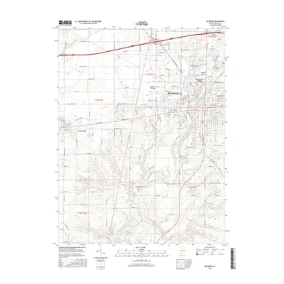
2016 Map of Richmond
USGS Topo · Published 2016About this map
The East Fork Whitewater River and its major tributaries, including Lick Creek and Elkhorn Creek, define the topography of Wayne County in this 2016 survey. This regional hub is centered on the city of Richmond, showing the modern footprint of educational institutions such as Earlham Coll, Indiana Univ E, and the Bethany Theological Seminary. The map provides a detailed view of the city's growth toward Spring Grove and East Haven, while to the west, the historic settlement of Centerville remains distinct.
Find a feature on this map
119 named features on this map. Tap any name to fly to it.
Don’t see what you’re looking for? This feature index may not catch every label — zoom into the map to look around manually.
Map Details
Editions of this 2016 Richmond Map
This is the sole edition of this map. No revisions or reprints were ever made.
Other maps of this area

1915 · New Paris
USGS Topo · 1:48,000

1915 · College Corner
USGS Topo · 1:48,000

1918 · College Corner
USGS Topo · 1:62,500

1918 · New Paris
USGS Topo · 1:62,500

1953 · Cincinnati
USGS Topo · 1:250,000

1956 · Brownsville
USGS Topo · 1:24,000

1957 · Cincinnati
USGS Topo · 1:250,000

1960 · Liberty
USGS Topo · 1:24,000

1960 · Fairhaven
USGS Topo · 1:24,000
1960 · Fountain City
USGS Topo · 1:24,000
Featured Places
- Richmond, IN
- Centerville, IN
- Spring Grove, IN
- South Richmond, Richmond
- Spring Grove Heights, Spring Grove